Black Hills Land Analysis LLC
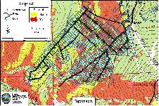 Using Geographic Information System (GIS) we can query, explore, and analyze data geographically. This can give you an understanding of your situation that wasn’t obvious before. This picture shows the topography and aspect in relationship to structures in this subdivision. South and west aspects are likely to have much more aggressive fire behavior because of the relationship of the sun to the fuels. Steeper slopes are also a factor.

Data collection using Trimble Geo explorer 3 makes data collection accurate and attributes are easily and efficiently collected.
The use of Pathfinder Office software ensures data integrity and accuracy by post processing field data before importing it into ArcView.